Address: North Cotabato
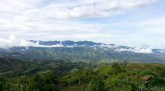
Description: Arakan Valley is a 4,024.73-hectare territory that represents the southern end of the Central Mindanao Cordillera and serves as home to the Manobo indigenous people. Primary growth forests have shrunk to less than 5% by the early 1990s due to massive commercial logging and land conversion for agricultural use, but further forest degradation has since been curtailed.
Status: On-going
|
Ecosystem Types |
Lowland to Sub-montane Forest |
|
Area |
4,024.73 hectares |
|
Biogeographic Highlights |
|
| Flora |
|
|
Fauna |
|
|
Indigenous People and Community |
|
|
Livelihood Resources |
|
Arakan Valley consists of cultivated and uncultivated lands (e.g., grasslands) in alluvial plains (>500 masl) and rolling to undulating lands in the footslopes and hilly lands (elevation 500-750 masl); Mid-montane (750-900 masl) farms and agro-forest plantations, secondary,and primary growth forests; high elevation (>900 masl) primary growth and mossy forest
Illegal logging is the primary extractive activity that severely affects Arakan Valley’s natural resource base. Land clearing for agriculture, including slash-and-burn practices, also create immense pressure on the forest cover.
Encroachment and population pressure drive the above extractive practices further.
Forest management in the two CADC areas where the Manobo populations reside needs to grapple with accelerated reduction of biodiversity, depletion of non-renewable resources, and soil degradation.
Difficulty in protecting the wilderness areas because of increasing population, extreme environmental conditions, and varied cultural traditions among the residents further compound the problem.
|
Project |
Grant Type, Strategy |
Duration |
Implementing Partners |
|
Arakan Indigenous Manobo Kulamanon-Tinanon Summit: Towards Furthering and Strengthening Indigenous Forest Governance For Climate Change Mitigation and Adaptation |
Small, Capacity-building |
2012 |
|
|
Forest Corridor Development Project In Arakan Valley, North Cotabato |
Large, Site-focused |
2009-2011 |
|
|
Participation Of Arakan Forest Carbon Project To The League Of Corporate Foudnations' Corporate Social Responsibility Expo 2009 |
Small, Constituency-building, Proactive |
2009 |
|
|
A Shift Towards Area Specific Intervention Through Strategic Planning for The FPE Priority Site In Arakan |
Medium, Site-focused, Proactive |
2007 |
|
|
Arakan Community-based Resource Management Project for Forest Corridor Development |
Medium to Large, Site-focused |
2000-2007 |
|
Biophysical resource assessment and community mapping conducted to provide baseline data for future conservation initiatives. Enterprise feasibility studies have also been implemented to cover the sustainable livelihood needs of the communities residing in the area.
Community leadership trainings, alongside documentation of indigenous knowledge, beliefs, systems and practices, have created means to capacitate the local community members while integrating traditional culture and knowledge systems in sustainable resource management practices.
Establishment of a forest corridor in the site as a means of connecting strips of forest that will allow wildlife to travel freely and safely across the main forest patches. In the long term, these efforts are expected to address the fragmentation of forest ecosystems, habitat loss, and species conservation in these important mountain ranges.
Partnership with LGUs, LGAs, other NGOs, and the academe are important factors in generating support that heightens the stakeholders recognition of the importance of protection, rehabilitation and conservation of the remaining forests’ biodiversity.
Foundation for the Philippine Environment. 2014. RSEA Guidebook (Results Booklet). Quezon City, Philippines: Foundation for the Philippine Environment.
Manipon AJN and Mesina SR. 2009. Communities, Conservation, and the Filipino Environmentalist. Quezon City, Philippines: Foundation for the Philippine Environment.
Foundation for the Philippine Environment. 2004. Sustaining Biodiversity Conservation Initiatives: Site Focused Projects 2003. Quezon City, Philippines: Foundation for the Philippine Environment.