Today is March 19, 2024
Export PDF

Mt. Matutum Protected Landscape

Mt. Matutum Protected Landscape

Address: South Cotabato

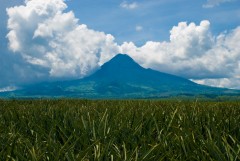
Description: Covering four municipalities, Mt. Matutum is a major watershed that supplies 25% of the water requirement of the SOCCSKSARGEN area. It is also home to various rare endemic birds and mammals, but destructive and unsustainable human activities, along socio-political influences are placing a heavy strain on the natural resources of the Mt. Matutum Protected Landscape.

Status: Closed

Site Profile Summary

Ecosystem Types

Lowland Forest

Protection Status

Protected Landscape (Presidential Proclamations No. 552)

Area

15,600 hectares

Biogeographic Features

  • Matutum is a landmark of the SOCSARGEN Growth Area and the headwater of five major rivers.

  • Covering four municipalities, it is a major watershed that supplies 25% of the water requirements of SOCSARGEN.

Flora


Fauna

  • It is believed to be one of the nesting areas of the critically endangered national bird, the Philippine eagle (Pithecophaga jeffryi)

  • Matutum is home yo some rare endemic birds, like the Mindanao Lorikeet (Trichoglossus johnstoniae), Mindanao Bleeding-heart (Gallicolumba criniger), and the Mindanao Broadbill (Eurylaimus steerii), to name a few.

  • Endemic subspecies of Snowy-browned Flycatcher (Ficedula hyperythra matutumensis). as well as mammals known only from Mount Matutum may already be in grave danger of extinction if current levels of forest lost and destruction continue,

Livelihood Resources

  • Logging

  • Farming

  • Mining

  • Hunting

Other Matters of Significance


Back to Map View
e-News Bulletin Join our mailing list today, and be ready for our next action alert. Enter a valid email address Enter your email address to receive regular news updates and announcements from FPE.